
Wayfinding Expansion
Overview
Aberdeen City Council is seeking to expand wayfinding provision in the city. To help us identify where the gaps are and what forms of wayfinding infrastructure should fill them, a consultation exercise was held in October 2018. You told us the following:
- Advanced wayfinding at gateways to the city centre would be very useful such as at the airport, beach, new harbour, railway stations and TECA and on approach;
- In the city centre, more information to help you find your way on foot near hotels, car parks, tourist attractions and transport interchanges would be really welcome;
- When in unfamiliar places, online maps, road signs and totem signs are the most popular forms for getting around.
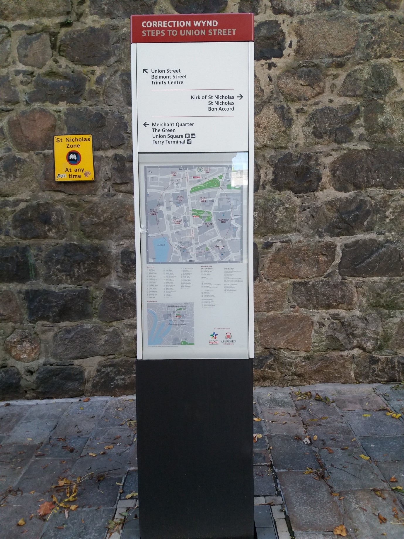
Given that online mapping services and road signs already exist, it is proposed to add to the existing network of wayfinding totems in the city centre to plug the gaps in both the city centre and its gateways and we want to know what you think. The totems are large white freestanding boards, containing maps and directions to popular destinations that pedestrians use to help find their way around. A picture is shown below.
This survey will present the justifications for each proposed location and give you the chance to suggest any changes. It will take around 10 minutes to complete.
This project has been made possible as part of Aberdeen City Council’s involvement in the CIVITAS PORTIS European Union funded project.
The following advanced locations are proposed:
1. Aberdeen Airport – A major gateway for visitors and those unfamiliar with the city. By having wayfinding information close to the city centre bus service, and by promoting all the facilities around the drop off points, the attractiveness of the service will be enhanced as will visitors’ desire to explore the city. Precise location within 'vestibule' at main entrance/exit.
2. Aberdeen Beach – One of the city’s most popular tourist attractions and a set down/pick up point for coaches. Wayfinding information directing people to the city centre will not only serve to highlight how close city centre facilities are to the beach but may also encourage travel there by foot. First totem to be located at the beach front, showing all local attractions as well as directing to a second sited at the Boulevard/Links Road junction providing more of a conventional city centre focus and serving as a useful node point en-route. A third at Beach Boulevard/ East North Street/ Commerce Street junction – a major decision point between the beach and the city centre – completes the chain.
3. Aberdeen Royal Infirmary – To be sited beside the bus turning circle. Complements existing ‘local’ wayfinding information and allows use of large, new car park to encourage bus use, in a similar vein to traditional P&R, rather than driving into city centre.
4. Aberdeen South Harbour – With potential for cruise ships, this could become a major gateway to the city for visitors and those unfamiliar with the city. Wayfinding information directing to the city centre will not only serve to highlight how close city centre facilities are to the harbour but may also encourage travel there by foot.
5. Dyce Station – A major gateway to the city, especially for visitors. If users of the rail service know where a train will drop them and what facilities they can find in the city once there, it will help to make the service more attractive and user friendly and might encourage them to spend more time in the city. To be locaited within covered waiting area on city bound platform.
6. TECA – A major destination within the city. Wayfinding information directing to the city centre will show people how close its facilities are to TECA, what is on offer and encourage them to visit.
The following additional City Centre locations are proposed:
7. South Silver Street – Great location halfway between Golden Square and Union Street junctions in the heart of the city centre. Complements nicely that totem already installed nearby on Union Street, with multiple surrounding trip generators to direct pedestrians towards. Specific nature of neighbouring Golden Square – where a totem cannot be installed owing to expensive-to-remove cobbles and an abundance of street furniture – with multiple streets leading off may cause confusion and enhances the merits of siting a totem here yet further.
8. Union Square Bus Station – Located within the covered waiting area by the benches, this totem would provide an effective ‘welcome’ and onward directions to the many arriving through this significant city gateway. Necessary to negotiate with relevant management as not our land. No road safety issues, however.
9. Shiprow (at NCP Car Park) – Exit from a major trip generator onto a lightly trafficked, 'pedestrians first' road with onward linkages to most major city centre attractions. Nicely complements existing totems at either end of Shiprow. Recommended to install on South side of exit and set against the building rather than position at kerbside due to the presence of tactiles and possible concerns aound visibility with the latter position.
10. Market Street/Harbour Junction (on Harbour side) – Provided sited on the Harbour side of the junction, a totem here has the potential to complement or indeed even replace the existing finger post – offering standardisation with other city centre totems – whilst providing a greater breadth of information allowing pedestrians to plan onward journeys to both the harbour and beyond towards the city centre. Additionally, a totem here allows those incoming pedestrians from the harbour to be ‘pushed’ toward the more desirable option of routing toward the city centre via Union Square. Crossover with harbour, another Civitas focus, fostering linkages with concurrent Harbour Links Project. Remove guard railing to facilitate possible pavement build out upon which totem could be sited. Potential issues around adopted road ending too soon.
11. Guild Street/Market Street Junction (north west side) – Sufficient distance away from the existing totem on the junction’s south west side (provided sited ‘around the corner’ on Market Street) and boasting adequate volume of trip generators within immediate locale (bus, train stations and Harbour) as well as being in a good position to ‘sign on’ to those of the city centre beyond. Adequate pedestrian infrastructure to enable safe use, more so than north east side.
12. Rosemount Viaduct/Woolmanhill Junction (north side) – Major junction at gateway to city centre overlooked by Central Library on north side, a significant trip generator.
13. Great Western Road/Holburn Street Junction – Gateway to city centre, to which a totem would offer an effective ‘welcome’ and directions to the many attractions within.
14. Donald’s Way/Rosemount Viaduct Junction – Appropriate location at the intersection of a popular pedestrian ‘cut through’ situated between the key trip generators of Central Library and His Majesty’s Theatre.
15. Summer Street/Huntly Street Junction (at Summer Street Car Park) – No existing totems within the vicinity of this public car park nicely placed within striking distance of Union Street and its many trip generators. Its small size may be detrimental to totem’s potential reach. High turnover suggests not an issue as well as catching ‘passing trade’. If information were provided in a strategic car park such as this one, it would not only promote the city centre and its facilities but would demonstrate how compact the city centre is and encourage people to walk between locations rather than drive between car parks. Totem to be sited beside either the main bins (where greater pavement width available) or grit bins (best location to ‘catch’ pedestrians entering/exiting car park), both locations on the car park’s periphery.
16. Chapel Street (at Chapel Street Car Park) – No information currently at this location, from which there exist many route options to popular destinations. ‘Cut through’ to Theatre, Library or towards Union Street. If information were provided in a strategic car park such as this one, it would not only promote the city centre and its facilities but would demonstrate how compact the city centre is and encourage people to walk between locations rather than drive between car parks.
17. Rose Street/Huntly Street Junction – Complements those totems proposed at Chapel Street (beside car park) and at Huntly Street/Summer Street junction and covers off corridor. Additionally, can potentially be used to route onwards toward Rosemount.
18. Littlejohn Street (top) – No existing totems within a vicinity which boasts multiple trip generators, some of which have only recently opened. Additionally, the setting at an intersection adds further impetus for installation at this location.
19. Littlejohn Street (bottom) – Complements that already in situ at West North Street/King Street Junction so makes sense to cover off the other angle and have one at West North St/ Littlejohn St junction in addition to that already proposed at top.
20. St. Andrew Street/Charlotte Street – Two major hotels – the Hilton Garden Inn and Sandman – are both situated on St Andrew Street and separated by Charlotte Street. Thus, siting totem at intersection makes sense.
21. St. Andrew Street/Blackfriars Street/Denburn Road – Prime entry point to the city centre and complements that proposed at St. Andrew Street/Charlotte Street.
Audiences
- Businesses
- Retailers
- Community Councils
- Community Organisations
- Tenants and Residents Associations
- Partner Agencies
- All Residents
- Bus Users
- Cyclists
- Shoppers
- Taxi Users
- Drivers
- Pedestrians
- People With Disabilities
- ACC Customers
- Carers
- Children and Young People
- Councillors
- Housing Tenants
- LGBT People
- Men
- Minority Ethnic Groups
- Older People
- Parents and Carers
- Road Users
- Students
- Visitors
- Women
- Young People
- ACC Staff
Interests
- Economic Development
- Retail
- Community Safety
- Community Planning
- Policies and Strategies
- Environment
- Sustainable Development
- Disabilities
- Gender
- Faith, Religion and Belief
- Race
- Sexual Orientation
- Arts and Culture
- Heritage
- Leisure
- Libraries
- Museums and Galleries
- Public Art
- Parks and Open Spaces
- Sport and Activities
- Tourism and Visitor Attractions
- Festivals and Events
- Cycling
- Parking
- Public Transport
- Roads and Pavements
- Traffic
- Transport
- Travel
- Walking
- Conservation
- City Centre Masterplan
- Development
- Land
- Masterplans
- Planning
- Property
- Public Space
- Regeneration
Share
Share on Twitter Share on Facebook